Destinations / North America
Bryce Canyon National Park, United States travel guide
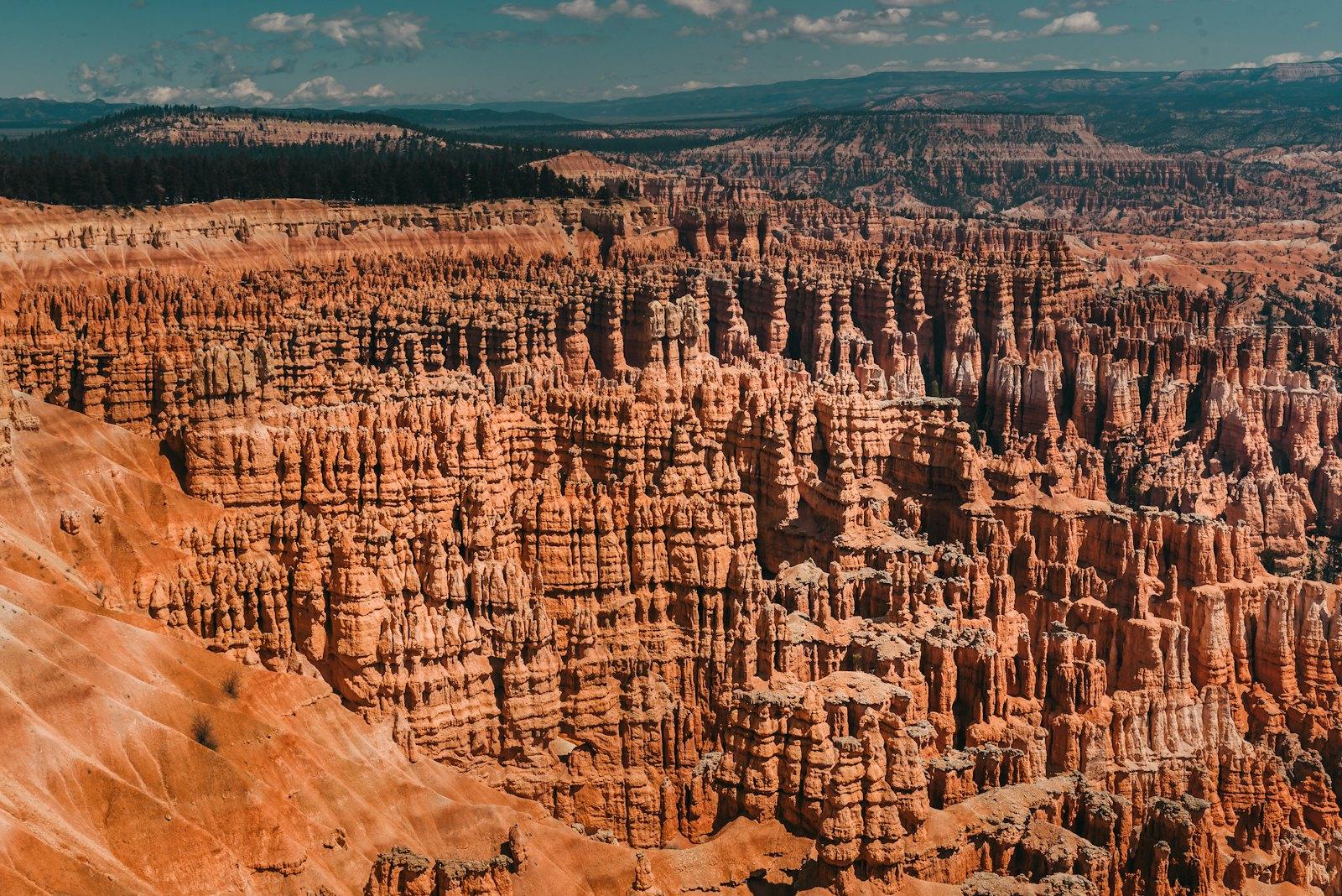
A fantasy landscape of thousands of rust-orange hoodoos: sunrise amphitheaters, rim-to-canyon hikes, and some of the darkest night skies in the country.
- Best time to visit: May to October
- Daily budget (budget traveller): $90 to $250 USD
- Ideal trip length: 2 to 3 days
Perched on the edge of the Paunsaugunt Plateau in southern Utah, Bryce Canyon National Park is less a canyon than a series of enormous natural amphitheaters filled with hoodoos, the slender, sculpted spires of red, orange, and cream rock carved by relentless freeze and thaw cycles. At elevations of roughly 8,000 to 9,000 feet, the park feels both intimate and vast, and the scale is easy to grasp for a solo traveller: a handful of rim viewpoints within a short walk of one another, a single scenic road running south to Rainbow Point, and trails that drop you straight into the forest of stone below. The Paiute people tell of the Legend People turned to stone here, and at sunrise, when the whole amphitheater glows, it is easy to see why the story endures. Add a quiet, friendly gateway community, a historic lodge, and an International Dark Sky Park designation that rewards anyone who stays up after dark, and Bryce becomes one of the most rewarding and manageable national parks to explore alone.
Bryce Canyon is not a canyon, and that is the first thing it gets right. It is a rim. The Paunsaugunt Plateau simply falls away in a series of east-facing amphitheaters, and the frost has spent a few million years sculpting the edge into the densest forest of hoodoos on Earth: thousands of rust, salmon and cream-coloured spires packed into a bowl. You walk to the lip at 8,000 to 9,100 feet, look down at a stone city, then hike into it. The Paiute name translates roughly as red rocks standing like men in a bowl-shaped recess, which is a better description than anything in the brochure. About 2 million people a year come, and most of them stay within a mile of Sunset Point.
That makes it one of the easiest national parks to do alone, and one of the easiest to do badly. The good version: you sleep close, you are at Bryce Point or Sunrise Point 45 minutes before first light (around 5:15am in June, closer to 7:30am in December), and you hike down Wall Street on the Navajo Loop while the tour buses are still eating buffet eggs at Ruby's Inn. Remember that here you descend first and climb out second, at altitude, so a 3-mile loop feels like 5. Bring more water than seems sane. After dark the park earns its International Dark Sky status. On a moonless night you can see more than 7,500 stars, and the rangers run free astronomy programmes, full moon hikes and the June Astronomy Festival, which are the best way to meet other solo travellers without forcing a conversation.
Plan Bryce as the middle of a route, not a destination. Highway 12, one of America's great scenic byways, runs east through Kodachrome Basin, Escalante and Boulder to Capitol Reef. Zion is about 1h45 west, and Cedar Breaks is a cool, high-elevation side trip. Practical rules: you need a car, services are thin, gas stations are in Bryce Canyon City, Tropic and Panguitch, and cell coverage drops out in the park. Everything is on Mountain Time, kitchens close by 9 or 10pm, and the nightlife is the sky. Do it right and two days is enough to fall for it. Three to four lets you see the places most visitors never walk.
Bryce Canyon National Park itinerary
Drive in, rim walk and first stars
Morning: Leave Las Vegas by 7am: I-15 north to Exit 95, Highway 20 east, US-89 south, then Highway 12 through the Red Canyon tunnels (about 4 hours). Stop at the Red Canyon Visitor Center for the 0.7-mile Pink Ledges Trail.
Afternoon: Check in at Ruby's Inn, buy lunch and water at Ruby's Inn General Store. Enter the park ($35 per vehicle for seven days, plus the nonresident fee unless covered by a qualifying pass) and walk the flat Rim Trail from Sunset Point to Sunrise Point (about half a mile one way).
Evening: Dinner at the Bryce Canyon Lodge dining room (reserve ahead). After dark, walk to Sunset Point with a red-light headlamp and let your eyes adapt for 20 minutes.
Sunrise at Bryce Point, Navajo + Queen's Garden
Morning: Drive to Bryce Point 45 minutes before sunrise. Then park at Sunset Point and hike the Navajo Loop down Wall Street, link to Queen's Garden and climb out at Sunrise Point (2.9 miles, about 625 feet of elevation gain, 2 to 3 hours). Check Wall Street is open, it closes in winter ice.
Afternoon: Late breakfast burrito or lunch at the Lodge, then rest. Walk the Rim Trail to Inspiration Point and ride the shuttle back.
Evening: Sunset from Sunset Point, then dinner at Cowboy's Buffet and Steak Room at Ruby's Inn. Join a ranger astronomy talk if one is on.
Peekaboo Loop and Rainbow Point
Morning: Start the 5.5-mile Peekaboo Loop from Bryce Point by 7:30am (about 1,500 feet of ups and downs, 3 to 4 hours). Give right of way to the guided horse strings and stand quietly on the uphill side.
Afternoon: Drive the 18-mile scenic road south: Natural Bridge, Agua Canyon, Ponderosa Canyon. At Rainbow Point (9,115 feet) walk the 1-mile Bristlecone Loop to Yovimpa Point.
Evening: Pie and a late dinner at Bryce Canyon Pines. If dates align, reserve a full moon hike through Recreation.gov; tickets are released 14 and 5 days ahead.
Fairyland Loop and Mossy Cave
Morning: Begin at Fairyland Point at 7am. The Fairyland Loop is 8 miles and about 2,300 feet of climbing, 4 to 5 hours with Tower Bridge on the way. Carry 3 litres of water.
Afternoon: Short and easy: the Mossy Cave trail on Highway 12 (under a mile, small waterfall, park admission is required; keep your pass or proof of admission with your vehicle). Then a long lunch in Tropic.
Evening: Golden hour at Inspiration Point, then dinner at the Lodge or a picnic on the rim.
Highway 12 to Calf Creek
Morning: Pack the car and drive Highway 12 east through Cannonville and Escalante (gas up in Tropic or Escalante). Coffee and a breakfast sandwich at Escalante Outfitters.
Afternoon: Hike Lower Calf Creek Falls (6.8 miles round trip, about 3 to 4 hours, $5 day-use fee). Then drive over the Hogback to Boulder.
Evening: Dinner at Hell's Backbone Grill and Farm in Boulder (reserve, seasonal), then sleep in Torrey.
Capitol Reef
Morning: Enter Capitol Reef National Park, drive the 8-mile Scenic Drive and walk the Hickman Bridge Trail (1.8 miles).
Afternoon: Hot fruit pie from the Gifford Homestead, then wander the Fruita orchards, where the fruit is free to pick in season.
Evening: Sunset at Panorama Point or Sunset Point, then dinner at Cafe Diablo in Torrey.
Slow start, head home
Morning: Late breakfast in Torrey. Highway 24 to I-70 is the quickest way out.
Afternoon: Salt Lake City is about 3h30 and Las Vegas about 5 hours. If your flight is late, Cathedral Valley or Goblin Valley are worth a stop.
Evening: Return the rental, with the gas tank full and the dust still on your boots.
Best neighbourhoods
- Bryce Amphitheater: The beating heart of the park, home to Sunrise Point, Sunset Point, Inspiration Point, and Bryce Point. Most of the famous hoodoo views and the main trailheads are clustered here, along the Rim Trail.
- Southern Scenic Drive: An 18-mile road running south from the visitor area to Rainbow Point at over 9,000 feet, passing overlooks such as Natural Bridge, Agua Canyon, and Yovimpa Point. It is quieter, cooler, and more forested than the amphitheater.
- Bryce Canyon City: The small gateway community just outside the park boundary, offering the widest choice of lodging, a general store, restaurants, and shuttle access. It is the most convenient base for early sunrise starts.
- Tropic and Highway 12: A peaceful rural town east of the park along the Highway 12 scenic byway, with a relaxed pace, local lodging, and easy access to the Mossy Cave trail and the wider red rock country towards Escalante.
Must-do experiences
- Watch sunrise from the rim: Arrive before first light at Sunrise Point or Bryce Point to watch the hoodoos shift from deep shadow to blazing orange. Bring a warm layer, as pre-dawn temperatures at this altitude are cold even in summer.
- Hike the Navajo Loop and Queen's Garden combination: Descend from Sunset Point through the narrow switchbacks of Wall Street, or down the Two Bridges side past Thor's Hammer when Wall Street is closed (it usually shuts in winter and after rockfall), then return via the Queen's Garden Trail to Sunrise Point. It is about three miles with a steady climb out, and the best single introduction to the park.
- Walk a section of the Rim Trail: Stroll the relatively flat path linking Sunrise, Sunset, and Inspiration Points for constantly changing views of the amphitheater. It is ideal for sunset, for easing into the altitude, or for a low-effort day.
- Drive to Rainbow Point and Yovimpa Point: Follow the scenic road to the southern end of the park, stopping at overlooks along the way, to gaze across vast distances of plateau and desert. Rainbow Point is the highest part of the park and often several degrees cooler than the rim near the visitor area.
- Tackle the Peekaboo Loop: Dive deeper into the canyon on this roughly five-mile loop that weaves through tunnels, arches, and close-up hoodoo scenery. Expect plenty of up and down, and note that the route is shared with guided horse rides.
- Stargaze under a dark sky: Bryce is an International Dark Sky Park, and on moonless nights the Milky Way arcs overhead in startling detail. Check the park calendar for ranger-led astronomy programmes and full moon hikes, which run during the warmer months.
Hidden gems
- Fairyland Point and the Tower Bridge trail on the northern edge of the park, where crowds thin out and the hoodoo views feel wonderfully private
- The Mossy Cave Trail along Highway 12, a short, easy walk to a small waterfall and a moisture-stained alcove that is especially lovely in cooler weather
- The Bristlecone Loop at Rainbow Point, a gentle trail through ancient bristlecone pines, some of which are over a thousand years old, with sweeping views across the plateau
- Ranger-led full moon hikes and night sky programmes, a memorable way to meet fellow travellers and see the hoodoos glowing under moonlight (check the seasonal schedule)
Daily budget
- Accommodation: budget $30-60 / night (NPS campsite or Ruby's Inn tent site), mid-range $180-320 (chain hotel or Tropic inn in peak season), splurge $320+ (Bryce Canyon Lodge, Under Canvas Bryce Canyon). Panguitch motels, about 30 min away, run $90-150 in summer and are the cheapest roof. Dispersed camping in Dixie National Forest is free.
- Food: budget $25-40 / day (groceries from Ruby's Inn General Store, one hot meal), mid-range $60-90 (Lodge dining room or Cowboy's Buffet dinner), splurge $120+ (dinner plus wine at the Lodge or Hell's Backbone Grill in Boulder). Pack lunches because there is no food on the trails. Groceries are cheaper in Panguitch or Cedar City than at the rim, and the pies at Bryce Canyon Pines are worth the detour.
- Transport: budget $60-90 / day (compact rental split, gas, free shuttle), mid-range $90-130 (SUV rental from Las Vegas or Salt Lake, gas), splurge $300+ (private guide with transport). You need a car. Las Vegas has the cheapest rentals, about $50-90/day in shoulder season. The park shuttle is free, but only a car gets you to Rainbow Point and Highway 12.
- Activities: budget $35 (vehicle pass, 7 days, all trails and ranger programmes free), mid-range $75-150 (Canyon Trail Rides canyon horse ride about $95, Kodachrome Basin $15), splurge $250+ (private photography guide or canyoneering day). An $80 America the Beautiful pass pays for itself at the third park. From 2026 non-US residents pay an extra $100 per person at Bryce, so check nps.gov/brca before you budget.
- Drinks & nightlife: budget $0-10 (free stargazing, grocery 5% beer), mid-range $20-35 (wine or cocktails at the Lodge, beer at Cowboy's Smokehouse in Panguitch), splurge $60+ (wine-paired dinner at the Lodge). Nightlife here is the Milky Way. Utah sells only 5% beer in supermarkets, and wine and spirits come from state DABS stores. Most kitchens close by 9 or 10pm.
Where to stay
- Social hostel in Bryce Canyon City / inside the park ($30-60 / night): There is no true hostel in the area. The closest equivalent is camping, with the NPS North Campground (about $30, reservable on recreation.gov) or Ruby's Inn campground for tent sites, with showers and a general store nearby. You will meet the hiker crowd round the picnic tables.
- Boutique hotel in Tropic ($250-400 / night): Stone Canyon Inn is a small, design-led stone-cabin property in a quiet farming town, about 25 minutes from the rim and far calmer than the Bryce Canyon City strip.
- Apartment in Panguitch or Tropic ($120-220 / night): Vacation rental cabins and casitas with a kitchen. Cheapest for 3+ nights, and saving $40 a day on meals adds up. Panguitch is about 30 minutes from the park and has the best groceries.
- Splurge in Rim of the amphitheater ($320-550 / night): Bryce Canyon Lodge, a 1920s National Historic Landmark steps from Sunrise Point (roughly April to October), or Under Canvas Bryce Canyon, safari-style glamping with stove-warmed tents.
What to eat
- Utah fry scones: pillowy, deep-fried dough served warm with honey butter or powdered sugar, a regional comfort food found in many local cafes
- Navajo tacos: crisp, golden fry bread piled with beans, seasoned meat, lettuce, tomato, and cheese, a filling meal after a long hike
- Bison burger: a lean, flavourful alternative to beef that appears on many menus in southern Utah
- Fresh trout: a classic Western staple, often pan-fried or grilled and served with seasonal vegetables at lodge and town restaurants
Day trips
- Kodachrome Basin State Park (45 min from Ruby's Inn): Odd stone chimneys, short trails like Angel's Palace, and far fewer people than Bryce. Add Grosvenor Arch on the graded Cottonwood Canyon Road on the way. Drive Highway 12 east to Cannonville, then 9 miles south on the paved Kodachrome Road. Day-use fee is about $15 per vehicle.
- Cedar Breaks National Monument (About 1h30 by car): A smaller, higher amphitheater at 10,000 feet with wildflowers in July and an even quieter feel. Road access is only open from late May to October. US-89 to Highway 143 to Highway 148 via Panguitch Lake. Entry is about $15 per person, covered by an America the Beautiful pass.
- Lower Calf Creek Falls (About 1h30 on Highway 12): A 6.8-mile round trip to a 126-foot waterfall and a cool swimming pool, with desert canyon walls and Highway 12 scenery all the way. Drive Highway 12 east through Escalante to the Calf Creek Recreation Area. Day-use fee is about $5 per vehicle.
When to visit
- Spring (April - May): 45-65°F (7-18°C) by day, freezing nights, windy, snow patches linger to May. Crowds: Low until Memorial Day. Quiet and cheap, but trails can be icy and the Rainbow Point road may be closed by snow. The shuttle generally operates April through mid-October; check NPS for current dates.
- Summer (June - August): 75-85°F (24-29°C) by day, 40-50°F nights, afternoon monsoon storms July to August. Crowds: Heavy, parking lots full by 10am. Great for stargazing and ranger programmes, but leave exposed areas whenever thunderstorms threaten. Book the Lodge and campsites months ahead and use the free shuttle.
- Autumn (September - October): 60-75°F (16-24°C) in September, 50-60°F by late October, cold dawns. Crowds: Moderate, drops hard after Labor Day. The sweet spot. Clear air, golden aspens on the southern drive, empty trails. Go mid-September to early October.
- Winter (November - March): 30-40°F (-1 to 4°C) by day, lows of 0-15°F (-18 to -9°C), regular snow. Crowds: Very low. Snow on orange hoodoos is the best photo you will take all year. Pack microspikes, expect the Lodge and some trails to be closed, and the road beyond Mile 3 can close temporarily during storms and snowplowing.
Entry rules for your passport
Visa rules for the United States depend on the passport you travel on. Check the official source before you book: U.S. Department of Homeland Security
Getting there
Bryce Canyon has no airport with regular airline service, so you fly into Las Vegas (LAS) or Salt Lake City (SLC), both about 270 miles and 4 hours away, then rent a car. Smaller alternatives: Cedar City (CDC, about 1h30, SkyWest flights from SLC) and St George (SGU, about 2h30 via Zion on Highway 9, flights from Salt Lake, Denver and Phoenix). From Las Vegas take I-15 north to Exit 95 (Highway 20), then US-89 south and Highway 12 east through Red Canyon. From Salt Lake City take I-15 south to US-89 south through Panguitch. Zion's east entrance is about 1h45 away, Capitol Reef about 2h15. There is no useful public transport, so rent in Las Vegas where it is cheapest and ask about one-way fees. Entry is $35 per private vehicle for 7 days ($20 per person on foot or bike), and non-US residents should check nps.gov/brca for the 2026 surcharge. The free park shuttle runs generally April through mid-October; check the current season’s schedule between Bryce Canyon City and the amphitheater viewpoints, but not to Rainbow Point. Fill your tank in Panguitch, Bryce Canyon City or Tropic.
Getting around
A car is essentially essential for reaching Bryce Canyon, as the park sits roughly 4 hours from both Las Vegas and Salt Lake City, and about 2 hours from Zion National Park. Cedar City and St. George have smaller airports with rental cars, and the area has very limited public transport. Inside the park, a free seasonal shuttle, which typically runs from spring through autumn, links Bryce Canyon City, the main viewpoints, and key trailheads, which is a relief when summer parking lots fill by late morning. Outside shuttle season, or for the southern scenic drive to Rainbow Point, you will want your own vehicle. Standard entry is $35 per private vehicle for seven days. Non-US residents aged 16 and over also pay $100 per person unless covered by a qualifying pass. No advance reservation or timed-entry booking is required to enter the park. Fill your tank and stock up on snacks and water in the gateway towns, as services inside the park are limited and mobile coverage can be patchy. Highway 12, one of America's great scenic byways, passes Red Canyon and the park boundary and makes a spectacular route between Bryce and Capitol Reef.
Safety
Bryce Canyon is generally very safe for solo travellers, with friendly rangers, well-marked trails, and plenty of fellow hikers on popular routes. The main risks are environmental. The park sits at 8,000 to 9,000 feet, so altitude can cause headaches, breathlessness, and fatigue, particularly on the climb back up from the canyon floor. Carry plenty of water, wear sun protection, and pace yourself. Summer afternoons often bring thunderstorms with lightning, so start hikes early and move off exposed rims if storms approach. In winter, expect snow, ice, and temperatures that fall well below freezing, so bring traction devices and warm layers, and check road and trail conditions before setting off. Stay behind railings and on marked trails, as rim edges are steep and rock is fragile and crumbly. Tell someone your plans, carry a downloaded offline map, and never feed or approach wildlife, including squirrels.
Solo travel tips
- Respect the altitude: The rim sits at 8,000 to 9,100 feet. Arrive, drink a lot, and save the big hikes for day 2. Climbing out of the amphitheater is where people get dizzy, so go slow and carry electrolytes.
- Do the full moon hike and astronomy programmes: Rangers run astronomy talks most nights in summer, plus free full moon hikes in the warmer months. Tickets are handed out at the visitor center a few days ahead and go fast, so grab one on arrival. It is the easiest way to end up chatting with other solo travellers.
- Start early and seek shelter when thunder threatens: July to September, thunderstorms build after midday and the rim is exposed to lightning. Hike at sunrise, rest at lunch, and watch the sky from the Lodge porch.
- Tell someone your route: Cell coverage is thin below the rim. Leave your plan with the front desk or a friend, carry a paper map, and note the trail names. The main amphitheater trails are busy, but side trails like Fairyland empty out.
- Solo female travellers: Bryce is very safe and busy at dawn and dusk. The real risks are cold, altitude and driving Highway 12 at dusk when mule deer are on the road. Park near other cars at trailheads and keep your phone charged.
- Find your tribe on the rim: The sunrise crowd at Bryce Point is mostly photographers, and they will happily swap tips. Canyon Trail Rides saddles up small groups from the Lodge, and the Peekaboo and Navajo trails are busy enough that you will rarely hike alone.
Cultural etiquette
- Stay on marked trails. The hoodoos are fragile, and shortcuts and climbing on formations are banned.
- Do not feed or approach the ground squirrels, chipmunks or deer. They get sick on human food and can bite.
- Yield to horses on the Peekaboo and other shared trails: step off on the uphill side, stay quiet, and let the guide lead.
- Uphill hikers have right of way on the climb out of the amphitheater, so step aside and take a breath.
- Use a red-light headlamp at stargazing events. White light ruins everyone's night vision and rangers will ask you to switch.
- Drones are banned in all national parks. Pack out all trash, including fruit peels.
- Utah towns are quiet on Sundays and many small-town shops and kitchens close early. Alcohol is limited and sold under state rules, so plan ahead.
Frequently asked questions
How do I get to Bryce Canyon National Park?
Most visitors fly into Las Vegas or Salt Lake City, each about 4 hours away by road, or into the smaller airports at Cedar City or St. George, then rent a car. Public transport to the park is very limited, so a rental car is the easiest option. Some guided day tours operate from larger cities, but schedules vary by season.
How many days do I need at Bryce Canyon?
Two to three days is ideal. That allows time for a sunrise at the rim, a canyon hike such as the Navajo Loop and Queen's Garden combination, a drive to Rainbow Point, and an evening of stargazing, without rushing. If you are short on time, a long day is enough for the highlights, but you will miss the best light and night skies.
When is the best time of year to visit Bryce Canyon?
Late spring and early autumn, roughly May to June and September to October, offer comfortable hiking temperatures and fewer crowds than midsummer. July and August are warmest but bring afternoon thunderstorms. Winter is cold and quiet, and the snow-dusted hoodoos are strikingly beautiful, though some trails and roads can be icy or closed.
How hard are the hikes, and will altitude affect me?
Many trails descend into the canyon first, which means the hard part is climbing back out at 8,000 to 9,000 feet. Allow extra time, take frequent breaks, and drink plenty of water. The Rim Trail and viewpoints are easy, while loops such as Peekaboo and Fairyland are strenuous. If you are coming from sea level, spend your first afternoon on gentle walks.
Is Bryce Canyon good for stargazing?
Yes, it is an International Dark Sky Park, and on clear, moonless nights the Milky Way is spectacular. The park runs ranger-led astronomy programmes and full moon hikes at certain times of year, and holds an annual astronomy festival, typically in summer. Dress warmly, as nights are cold even in July.
Where should I stay as a solo traveller?
Options include the historic Bryce Canyon Lodge inside the park (seasonal), park campgrounds, and a range of motels, cabins, and campgrounds in Bryce Canyon City, Tropic, and Panguitch. Summer is busy, so book accommodation and campsites well in advance. Staying in or near Bryce Canyon City makes early sunrise starts and shuttle access easiest.
Is Bryce Canyon safe for solo female travellers?
Yes, the park and nearby towns are considered very safe, with plenty of other visitors on popular trails and helpful rangers at the visitor centre. Standard precautions apply: tell someone your plans, carry water and a downloaded map, start hikes in daylight, and be cautious in remote areas where phone service is unreliable.
What entry rules apply to international travellers visiting Bryce Canyon in 2026?
Bryce Canyon is in the United States, so international visitors must meet US entry requirements, which generally means a valid passport and either a visa or approval through the Visa Waiver Program (ESTA) depending on nationality. You will also pay a park entrance fee or show a valid national parks pass, and fees for non-US residents can differ at some parks. Rules change, so always check the official sources, including the US Department of State, US Customs and Border Protection, and the National Park Service website, before you travel.
Tours and activities in Bryce Canyon National Park | Bryce Canyon National Park in 2 days | Bryce Canyon National Park in 3 days | Bryce Canyon National Park in 4 days | Bryce Canyon National Park in 5 days | Bryce Canyon National Park in 7 days
Can't decide? Compare Bryce Canyon National Park with...
Joy Plus home | Destinations | Itineraries | Activities | Flights | Budget planner | Calendar | Map | Blog | Lifetime access